Policymakers, researchers, and organizations need agricultural statistics to monitor production changes, plan future investments and interventions, and estimate crop outputs. However, poor agricultural data can result in disastrous misallocations of resources and unsuccessful policies, as well as having a dire impact on both populations and farmers.
Jacques Delincé, a veteran agricultural statistician and former head of Agrilife and MARS units at the European Commission, is currently working as a consultant for the Food and Agriculture Organization – or FAO – on the Global Strategy to Improve Agriculture and Rural Statistics. By comparing the accuracy and costs of list and area frames for farmer surveys, the team seeks to find more cost-effective methods for agricultural statistics in developing countries.
By conducting farmer interviews, data is collected by asking farmers to estimate the area of planted crops in their fields or farms using regular household questionnaires. On the other hand, an area frame survey is a global estimate derived from a sample of well-defined land units.
The FAO has conducted ground data collection surveys in Nepal and Brazil. Ground surveys have many advantages but can also be costly and require strict quality control procedures to ensure data integrity. In addition, accuracy still needs to be addressed, despite rigorous statistical modelling approaches, as cost considerations often limit sample sizes.
As Earth observation data becomes more affordable and accessible, ground-based systems may be supplemented with satellite imagery in the coming years. In addition, aerial images may be the only way to survey areas where civil wars and violence make them unsafe.
Delincé and his team opted to combine recent remote-sensed data with ground surveys from the current year to save costs while working in Rwanda. To get an accurate estimate of crop surface areas, Delincé could analyze aerial images from the exact location and apply the same discriminating methodology to satellite images of the entire country if the team could get crop area results similar to the ground surveys.
Global Strategy’s team used images from Sentinel-2, Landsat-8, and Sentinel-1 to analyze Rwanda. Rwanda is approximately the size of Maryland, so satellite imagery is often more economical than drones or planes for this country.
Drones can cover small, defined areas, but regulations vary greatly by location. In addition, there are many obstacles to full area coverage, such as line-of-sight rules, which require the pilot always to be able to see the drone, and large no-fly zones around buildings, such as airports and hospitals with helipads.
However, planes offer significant savings over high-resolution satellite images because they cover large surfaces efficiently, are less susceptible to cloud coverage problems, and offer less expensive images than satellites. As with drones, statistics and scientists are restricted from flying over certain areas due to military or government restrictions.
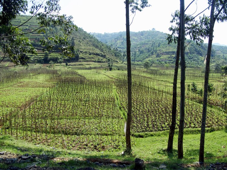
In the context of African farming systems, it is even more challenging to estimate crop areas accurately from aerial images. Smallholder farms in Sub-Saharan Africa tend to produce a wide array of diverse crops, non-uniform plots with varying sizes – sometimes only a few meters square – and intercropping, which is when farmers plant different crops in the same field.
Despite this, the preliminary results of the Rwanda study were inconclusive. The spatial resolution of open data used, 15 and 10 meters, was too coarse for proper differentiation between cultures in Rwanda. Despite this, Global Strategy’s research will allow Rwandan governments and NGOs, both global and local, to better estimate future crop allocations, develop help plans for farmers, and even model the impact of specific food subsidies on the local economy.
To improve results accuracy further and widen the applicability, the team is now looking into sub-meter satellite data. As satellite sensors continue to sharpen and Earth observation data access improves over time, programs like the FAO Global Strategy will develop even more cost-efficient methods to improve Agriculture and Rural Statistics for developing countries.