

Sun-synchronous low Earth orbits
Understanding orbits is simpler than one might think. In the same way as consumer cameras, the closer you are to the object you want to capture, the more details you can see. Satellites in Low Earth Orbit (LEO) can capture images of high resolution because they are closer to the object they are trying to capture.
An Earth observation satellite follows a sun-synchronous orbit, also called a polar or near-polar orbit, going north to south so that it stays at low altitudes without falling back towards the ground and passes over daylight-covered areas as much as possible. In Low Earth Orbits, altitudes can range from 200 km to 1,000 km (120 - 620 mi) and orbital speeds from ~7.1 km to ~7.8 km per second (4.4 to 4.8 mi/s).
A sun-synchronous orbit takes approximately an hour and a half to two hours before coming back to the same latitude and starting a new ascent. In those 90-120 minutes, the Earth rotated enough to allow the satellite now to fly over a slightly different area of the globe.
This also means:
- The local solar time at a specific location will always be the same whenever the satellite passes over.
- It takes hundreds of rotations and several days for a satellite to fly over the same spot on the globe.
An entire revolution around the Earth, flying back over the same spot on the planet, is called the "Temporal resolution."
VISUAL REPRESENTATION
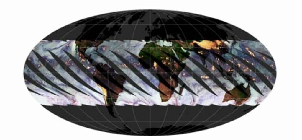
A Low Earth Orbit satellite passes over the Earth at noon (from the North pole to the South pole) and midnight (from the South pole to the North pole).
The tracks covered by the Tropical Rainfall Measuring Mission (TRMM) satellite, which was launched by NASA to monitor rainfall in the tropics.
The propulsion mechanisms of some satellites are used to keep the satellite in orbit and compensate for height and tilt changes rather than to change its course. Maintaining a satellite in a Sun-synchronous orbit takes regular adjustments due to the drag of the atmosphere and gravity from the Sun and Moon.
While the satellite doesn't deviate from orbit, sometimes they can orient their sensors to help capture slightly off-path scenes, or in satellite lingo, “off-nadir,” nadir being the point directly under the satellite. Using this technique, more interesting data or scenes not covered by clouds can be captured in one temporal resolution.
Geo-synchronous orbits
Geostationary satellites orbit the Earth above the equator at an altitude of 36,000 km. Their orbital velocity is 3 km per second (1.9 mi/s). Geostationary satellites are fixed around a specific point around the planet for a period of 24 hours.
It can cover a larger area of the Earth at once than geosynchronous satellites, which have much lower spatial resolutions (what can be seen on the ground). Besides monitoring large-scale weather patterns and global events, they are also heavily used for communication (phones, television, radio, GPS).